Autonomous Navigation in Duckietown with QuackCruiser

QuackCruiser: Autonomous Navigation with Dijkstra

QuackCruiser: Autonomous Navigation with Dijkstra

Project Resources

Autonomous navigation in Duckietown with QuackCruiser - objectives and approach

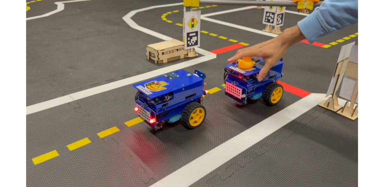
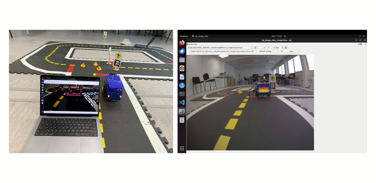
The objective of this project is to implement autonomous navigation in Duckietown by integrating perception, Dijkstra planning, and control into a Duckiebot (DB21J).

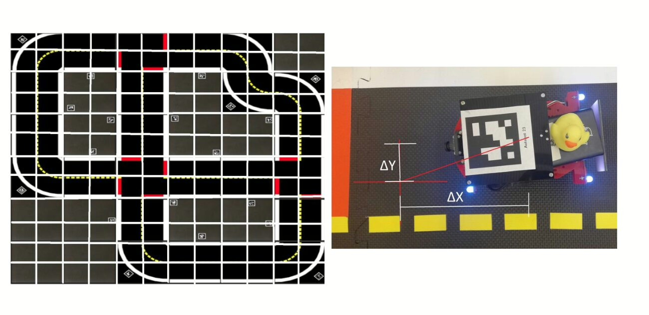
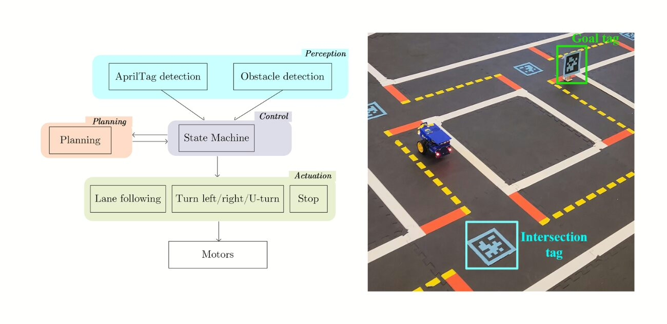
Localization at intersection is achieved using AprilTag detection, YOLO-ROS is used for real-time obstacle recognition, and onboard sensors such as wheel encoders and IMU are used for odometry. These inputs provide both exteroceptive data (from the environment) and interoceptive data (from the robot itself), which are fused to estimate pose and environment state.

Planning is performed with Dijkstra planning algorithm, a graph search method that computes the shortest path on a grid-based map where intersections are nodes and lanes are edges with associated costs.

Control is implemented through PID-based lane following and parameterized turning services, where each maneuver is defined by velocity, radius, and execution time. A ROS state machine coordinates perception inputs and planning outputs to trigger the correct control actions in ‘real time’.

Autonomous navigation in Duckietown with QuackCruiser - highlights

The challenges

The principal challenges in implementing this agent emerge from hardware calibration, computational limitations, and cross-module synchronization.

Wheel encoder calibration directly influences odometric drift, while camera calibration governs the reliability of AprilTag-based localization and lane geometry estimation. The deployment of CUDA-accelerated YOLO models within the ROS ecosystem introduces compatibility constraints across GPU drivers, compiler toolchains, and real-time inference pipelines, which collectively impose significant computational overhead on limited embedded resources.

At the system integration level, temporal synchronization across perception modules (AprilTag detection, obstacle detection) and control modules (lane following, turning) constitutes a critical factor, as phase offsets and latencies propagate into localization uncertainty and trajectory deviation.

Sensor fusion must accommodate inconsistency between odometry estimates and visual updates, with conflict resolution strategies directly shaping the stability of pose estimation.

Furthermore, the tuning of control gains and maneuver execution parameters remains non-trivial, since cumulative deviations over extended trajectories amplify minor discrepancies in actuation dynamics and timing precision.

Looking for similar projects?

Autonomous navigation in Duckietown with QuackCruiser: authors

Yunwem Li is a Computer engineering graduate with a master’s in robotics from ETH Zurich, Switzerland.

Farian Keck is currently working as an Autonomy intern at Airbus Defence and Space , Switzerland.

Jiranyi has a master’s in robotics from ETH Zurich, Switzerland.

Learn more

Duckietown is a modular, customizable, and state-of-the-art platform for creating and disseminating robotics and AI learning experiences.

Duckietown is designed to teach, learn, and do research: from exploring the fundamentals of computer science and automation to pushing the boundaries of knowledge.

These spotlight projects are shared to exemplify Duckietown’s value for hands-on learning in robotics and AI, enabling students to apply theoretical concepts to practical challenges in autonomous robotics, boosting competence and job prospects.

Visual Feedback for Autonomous Navigation in Duckietown

Features for Efficient Autonomous Navigation in Duckietown

Features for Efficient Autonomous Navigation in Duckietown

Project Resources

Project highlights

Visual Feedback for Autonomous Navigation in Duckietown - the objectives

This project from students at TUM (Technische Universität of Munich) builds on the preexisting Duckietown autonomy stack to add/reintegrate/improve upon much-needed autonomous navigation features: improved control (pure pursuit instead of PID), red stop line detection, AprilTag detection, intersection navigation, and obstacle detection (using YOLO v3), making Duckietowns more complex and interesting!

The resulting agent includes modules for lane following, stop line detection, and intersection handling using AprilTags, following the legacy infrastructure of Duckietown.

The autonomy pipeline relies heavily on vision as the primary means of perception: lane edges are projected from image space to the ground plane using inverse perspective mapping learned after running a camera calibration procedure.

The Duckiebot then estimates a dynamic target point by offsetting yellow or white lane markers depending on visibility. The curvature is computed based on the geometric relation between the Duckiebot and the goal point, and the steering command is derived from this curvature.

The Duckiebot velocity and angular velocity are then modulated using a second-degree polynomial function based on detected path geometry.

Visual input from an onboard monocular camera is processed through a lane filter with adaptive Gaussian variance scaling relative to frame timing.

When running by an intersection, stop lines are detected using HSV color segmentation. AprilTag detection determines intersection decisions, with tag IDs mapped to turn directions.

Every module is implemented as an independent ROS package with dedicated launch files, coordinated via a central launch file. A YOLOv3 object detection model, trained on a custom Duckietown dataset, provides real-time obstacle recognition.

The challenges and approach

One major hurdle was integrating object detection models like Single-Shot Detector (SSD) and YOLO with the Duckiebot’s ROS-based camera system.

While the SSD model was trained on a custom Duckietown dataset, ROS publisher-subscriber mismatches prevented live inference. Transitioning to the YOLO model involved adapting annotation formats and re-training for compatibility with the YOLO architecture. In lane following, the default controller from Duckietown demos showed high deviation, prompting the implementation of a modified pure pursuit approach. 

Additional challenges arose from limited computational resources on the Duckiebot, with CPU overuse causing processing delays when running all modules concurrently. The approach focused on modular development, isolating lane following, stop line detection, and intersection navigation into separate ROS packages with fine-tuned parameters. The pure pursuit algorithm was adapted for ground-projected lane estimation, dynamic speed control, and target point calculation based on visible lane markers. Integration of AprilTag-based intersection logic and LED signaling provided directional control at intersections.

This structured, iterative methodology enabled real-time, vision-guided behavior while operating within the constraints.

Project Report

Did this work spark your curiosity?

Visual Feedback for Autonomous Navigation in Duckietown: Authors

Servesh Khandwe is currently working as a Software Engineer at Porsche Digital, Germany.

Ayush Kumar is currently working as a Research Assistant at Fraunhofer IIS, Germany.

Parth Karkar is currently working as an Analytical Consultant at Mutares SE & Co. KGaA, Germany.

Learn more

Duckietown is a modular, customizable, and state-of-the-art platform for creating and disseminating robotics and AI learning experiences.

Duckietown is designed to teach, learn, and do research: from exploring the fundamentals of computer science and automation to pushing the boundaries of knowledge.

These spotlight projects are shared to exemplify Duckietown’s value for hands-on learning in robotics and AI, enabling students to apply theoretical concepts to practical challenges in autonomous robotics, boosting competence and job prospects.

Autonomous Navigation System Development in Duckietown

Autonomous Navigation System Development in Duckietown

Autonomous Navigation System Development in Duckietown

Project Resources

Project highlights

Autonomous Navigation System Development in Duckietown - the objectives

The primary objective of this project is to develop and refine an Autonomous Navigation System within the Duckietown environment, leveraging ROS-based control and computer vision to enable reliable lane following and safe intersection navigation. This includes calibrating sensor inputs, particularly from the camera, IMU, and encoders, and integrating advanced algorithms such as Dijkstra algorithm for optimal path planning. The project aims to ensure that the Duckiebot can autonomously detect lanes, stop lines, and obstacles while dynamically computing the shortest path to any designated point within the mapped environment. Additionally, the system is designed to transition smoothly between operational states (lane following, intersection handling, and recovery) using a refined Finite State Machine approach, all while maintaining robust communication within the ROS ecosystem.

Project Report

The challenges and approach

The project faced several challenges, beginning with hardware constraints, such as the physical limitations of wheel traction and battery lifespan, which affected motion stability and operational time. The integration of various ROS packages, some with incomplete documentation and inconsistent coding practices, complicated the development of a reliable and maintainable codebase. The method adopted involved precise sensor calibration to ensure accurate perception and control, incorporating camera intrinsic and extrinsic calibration for improved visual data interpretation, and adjusting wheel parameters to maintain balanced motion. The lane following module required parameter tuning for gain, trim, and heading correction to adapt to Duckietown’s environment. The original FSM-based intersection navigation system was re-engineered due to unreliability in node transitions, replaced with a distance-based approach for intersection stops and turns, ensuring deterministic and reliable behavior. Dijkstra’s algorithm was implemented to create a structured graph representation of the city map, enabling dynamic path planning that adapts to real-time inputs from the perception system. Custom web dashboards built with React.js and roslibjs facilitated monitoring and debugging by providing live data feedback and control interfaces. Through this rigorous and iterative process, the project achieved a robust autonomous navigation system capable of precise path planning and safe maneuvering within Duckietown.

Did this work spark your curiosity?

Autonomous Navigation System Development in Duckietown: Authors

Julien-Alexandre Bertin Klein is currently a Bachelor of Science (BSc.), Information Engineering at the Technical University of Munich, Germany.

Andrea Pellegrin is currently a Bachelor of Science (BSc.), Information Engineering at the Technical University of Munich, Germany.

Fathia Ismail is currently a Bachelor of Science (BSc.), Information Engineering at the Technical University of Munich, Germany.

Learn more

Duckietown is a modular, customizable, and state-of-the-art platform for creating and disseminating robotics and AI learning experiences.

Duckietown is designed to teach, learn, and do research: from exploring the fundamentals of computer science and automation to pushing the boundaries of knowledge.

These spotlight projects are shared to exemplify Duckietown’s value for hands-on learning in robotics and AI, enabling students to apply theoretical concepts to practical challenges in autonomous robotics, boosting competence and job prospects.

Path Planning for Multi-Robot Navigation in Duckietown

Path Planning for Multi-Robot Navigation in Duckietown

Path Planning for Multi-Robot Navigation in Duckietown

Project Resources

Project highlights

Path planning for multi-robot navigation in Duckietown - the objectives

Navigating Duckietown should not feel like solving a maze blindfolded!

The “Goto-N” path planning algorithm gives Duckiebots the map, the plan, and the smarts to take the optimal path from here to there, without wandering around by turning the map into a graph and every turn into a calculated choice.

While Duckiebots have long been able to follow lanes and avoid obstacles, truly strategic navigation, thinking beyond the next tile, toward a distant goal, requires a higher level of reasoning. In a dynamic Duckietown, robots need more than instincts. They need a plan.

This project introduces a node-based path-planning system that represents Duckietown as a graph of interconnected positions. Using this abstraction, Duckiebots can evaluate both allowable and optimal routes, adapt to different goal positions, and plan their moves intelligently.

The Goto-N project integrates several key concepts like:

  • Nodegraph representation: transforms the tile-based Duckietown map into a graph of quarter-tile nodes, capturing all possible robot positions and transitions.

  • Allowable and optimal move generation: differentiates between all legal movements and the most efficient moves toward a goal, supporting informed decision-making.

  • Termination-aware planning: computes optimal actions relative to a chosen destination, enabling precise goal-reaching behaviors.

  • Multi-robot scalability: validates the planner across one, two, and three Duckiebots to assess coordination, efficiency, and performance under shared conditions.

  • Real-world implementation and validation: demonstrates the effectiveness of Goto-N through trials in the Autolab, comparing planned movements to real robot behavior.

The challenges and approach

Navigating Duckietown poses several technical challenges: translating a continuous environment into a discrete planning space, handling edge cases like partial tile positions, and enabling efficient coordination among multiple autonomous agents.

The Goto-N project addresses these by discretizing the Duckietown map into a graph of ¼-tile resolution nodes, capturing all possible robot poses and orientations. 

Using this representation, the system classifies allowable moves based on physical constraints and tile connectivity, then computes optimal moves to minimize distance or steps to a termination node using heuristics and precomputed lookup tables.

A Python-based pipeline then ingests the map layout, builds the nodegraph, and generates movement policies, which are then validated through simulated and physical trials. The system scales to multiple Duckiebots by assigning independent paths while analyzing overlap and bottlenecks in shared spaces, ensuring robust, efficient multi-robot planning.

Path planning (Goto-n) in Duckietown: full report

The design and implementation of this path planning algorithm is documented in the following report.

Path planning (goto-n) in Duckietown: Authors

Alexander Hatteland is currently working as a Consultant at Boston Consulting Group (BCG), Switzerland.

Marc-Philippe Frey is currently working as a Consultant at Boston Consulting Group (BCG), Switzerland.

Demetris Chrysostomou is currently a PhD candidate at Delft University of Technology, Netherlands.

Learn more

Duckietown is a modular, customizable, and state-of-the-art platform for creating and disseminating robotics and AI learning experiences.

Duckietown is designed to teach, learn, and do research: from exploring the fundamentals of computer science and automation to pushing the boundaries of knowledge.

These spotlight projects are shared to exemplify Duckietown’s value for hands-on learning in robotics and AI, enabling students to apply theoretical concepts to practical challenges in autonomous robotics, boosting competence and job prospects.

Smart Lighting: Realistic Day and Night in Duckietown

Smart Lighting: Realistic Day and Night in Duckietown

Smart Lighting: Realistic Day and Night in Duckietown

Project Resources

Project Highlights

Here is the output of the authors’ work on smart lighting autonomous driving.

Why day and night autonomous driving in Duckietown?

Autonomous driving is already inherently hard. Driving at night makes it even more challenging! This is why smart lighting is an interesting application that intersects with autonomous driving: having city infrastructure, such as traffic lights and watchtowers, generate dynamically varying light – only where and when they’re needed – to make driving at night not only possible but safe. Here are some reasons for which this project is interesting:

Realistic driving scenarios: autonomous driving systems must handle varying lighting conditions. Day and night cycles are just the beginning: transitions like sunrise or sunset make the spectrum of experimental corner cases more complex, hence Duckietown a valuable testbed.

Robust lane-following capabilities: developing an adaptive lighting system in which the city infrastructure “collaborates” with Duckiebot to provide optimal driving scenarios reinforces driving performances and general robustness for lane following.  

Decentralized control for scalability: a decentralized approach to managing lighting implies that the system can be scalable across Duckietowns of arbitrary dimensions, making it more adaptable and resilient.

Autonomous lighting management: a responsive street lighting system, working in tandem with the Duckiebot’s onboard sensors, improves energy efficiency and ensures safety by adjusting to local lighting needs automatically.

Smart Lighting: Realistic Day and Night in Duckietown - the challenges

Implementing smart lighting in Duckietown to improve autonomous driving during day and night cycles presents several challenges. Here are a few examples: 

Hardware modifications: while Duckiebots are equipped with controllable LEDs, city infrastructure does not possess lighting capabilities out of the box. The first step is integrating light sources in the design of Duckietown’s city infrastructure.

Variable lighting conditions: Duckiebots, which in this project rely uniquely on vision in their autonomy pipeline, must adapt to changing lighting conditions such as full darkness, sunrise, sunset, and artificial lighting, which impacts camera vision and lane detection accuracy.

Decentralized control: managing street lighting in a decentralized way across Duckietown ensures that each area adapts to its local lighting needs, compensating for example for the presence of passing Duckiebots with their own lights on. Join control algorithms including both city infrastructure and vehicle lighting intensity add complexity to the system’s design and coordination.

Scalability: the street lighting system must be scalable across the entire city, requiring a design that can be expanded without significant complications.

Safe and reliable operation: the system needs to be safe, adapting to issues such as occasional watchtower lighting source failure, while ensuring consistent lane-following performance.

Smart Lighting: Realistic Day and Night in Duckietown: Results

Smart Lighting: Realistic Day and Night in Duckietown: Authors

David Müller is a former Duckietown student of class Autonomous Mobility on Demand at ETH Zurich, and currently works as a Research Engineer at Disney Research, Switzerland.

Learn more

Duckietown is a modular, customizable and state-of-the-art platform for creating and disseminating robotics and AI learning experiences.

It is designed to teach, learn, and do research: from exploring the fundamentals of computer science and automation to pushing the boundaries of knowledge.

Project parking in Duckietown

Introducing Autonomous Parking in Duckietown Cities

Introducing Autonomous Parking in Duckietown Cities

Project parking in Duckietown
Project Resources

Why Autonomous Parking?

Parking is notoriously a hard task to master for many humans. Hence, students of the Autonomous Mobility on Demand course at ETH Zurich wanted to determine to what degree this applied to autonomous parking with Duckiebots. 

The goal of the Autonomous Parking project was to design, implement, and test a complete autonomous parking solution compliant with the Duckietown ecosystem.

Duckiebots should be able to enter and exit a parking area, identify viable parking lots, actually park and exit their parking spot safely, and avoid collision with other Duckiebots during the entire process. 

The vision is to integrate autonomous charging solutions into the parking area, so Duckiebots can charge themselves when needed.

Autonomous parking in Duckietown: the challenges

Leveraging the Duckietown lane following vision baseline provided a basic infrastructure to build upon.

Some technical challenges specific to this projects were:

Backward Lane Following: Duckiebots must drive backward to exit the parking lots but only have cameras on the front. It is required to adjust the Duckiebot’s control system for stable backward driving, by changing the pose estimation process and re-tuning the PID controller.

Dynamic Color Adaptation: the new parking lot design introduced additional appearance specifications to the Duckietown city setup, such as blue lines identifying parking areas. Modifying the Duckiebots’ native lane detector to recognize blue lines in addition to yellow, red, and white, allows for additional flexibility in lane following based on specified colors.

Time Slot Coordination: Managing the availability of parking spaces is crucial to minimize the probability of collisions between Duckiebots. This project tackled this challenge by implementing a time-slot system to manage parking exits to prevent collisions, using red LEDs for signaling to other Duckiebots.

Project Highlights

Here is a visual tour of the work of the authors.

Check out the documents for more details!

Project Parking Results

(Turn on the sound for best experience!)

Project Authors

Trevor Phillips is a former Duckietown student, now a Machine Learning SWE at Apple in Switzerland. 

Vincenzo Polizzi

Vincenzo Polizzi is a former Duckietown student, now a Ph. D. student at the University of Toronto, Canada.

Linus Lingg

Linus Lingg is a former Duckietown student, now the Co-Founder and CTO of bottleplus in Switzerland. 

Learn more

Duckietown is a modular, customizable and state-of-the-art platform for creating and disseminating robotics and AI learning experiences.

It is designed to teach, learn, and do research: from exploring the fundamentals of computer science and automation to pushing the boundaries of knowledge.